Washington Co. > Homes and Buildings > Glade Spring area - 1821 and 1890 maps
The two maps below were created 70 years apart. The 1821 map focused on the buildings along the Great Wagon Road (also known as the Great Rd. or the Old Stage Rd.) whereas the 1890 map covered a wider area. Many of the homes identified by owner on the 1821 map are also identified by owner on the 1890 map. See charts below the 1890 map.
1821 - John Wood Map
The brown line indicates the Old Wagon Rd./Old Stage Road. The wide, wavy line below it is the Middle Fork of the Holston River. Locate Glade Spring Church as a reference point.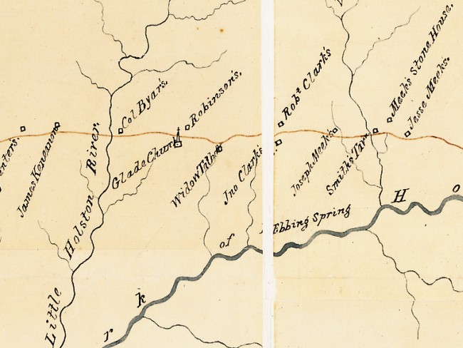
1890 - C.R. Boyd Map
This map also shows the Old Stage Rd., Glade Spring Church and the Middle Fork of the Holston River. Many additional roads are indicated, as well as a railroad line.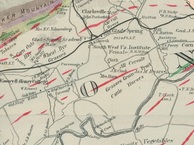
The 3 charts below list several homes that were identified on both maps. Column 1 lists the owner's name on the 1821 map and column 2 lists the owner on the 1890 map. The charts also identify a few homes that were labeled on one map but not the other.
Homes and Buildings along the Old Stage Rd.
| 1821 Map | 1890 Map | Comment |
|---|---|---|
| Col. Byar's | Mrs. Ernest | In 1821 Col Byars lived at the first Brook Hall; a few years later he built the much larger (second) Brook Hall across the Old Stage Rd. It was occupied by his daughter, Amanda (Byars) Ernest in 1890 |
| Glade Church | Gl Sp Church | See the slideshow showing wind damage sustained by the church in 2009 |
| Widow Talbut | Mrs. Horn | The "widow Talbot" was Mary (Logan) Talbert. She and her husband Bazel purchased 328 acres on both sides of the Great Rd. from George and Ann Kincannon in 1807. Bazel and Mary ran a Stagecoach Inn on the property. Bazel died in 1818, but Mary continued to run the inn. After Mary's death the inn was owned by her daughter and son-in-law Isaac and Eliza (Talbert) Horne who outlived both of their children. "Mrs. Horn" on the 1890 map was Ann Elizabeth (Gose) Horne, the widow of Isaac and Eliza's son William Talbert Horne. Ann Elizabeth's son William Basil Horne, who was 18 in 1890, lived in the old inn until his death in 1960 |
| Robinson's | (unlabeled square opposite Gl Sp Church, north side Gr. Rd. and west of creek) | By 1812 John Robinson held sole title to 180 acres on both sides of the Great Rd. John Robinson's log home, indicated on the 1821 Wood's map, no longer stands. John may have built it or it may have been built by Francis Kincannon who settled the land about 1869, or by Francis's son Mathew Kincannon. In the 1850s John's son Ebenezer Alexander ("E.A.") Robinson built a brick home on the property. In 1937 Ebenezer's sons noted that the John Robinson log home had sat near the present brick structure. The E.A. Robinson home, and surrounding land, is still owned by the Robinson family. |
| W.B. Mason (square on north side Gr. Rd and east of creek) | Dr. Nickerson Snead purchased two tracts of land along the Great Rd. in the 1830s on which he and his wife Elizabeth (Scott) Beattie Snead built a large brick home. Nickerson died in 1869 leaving Elizabeth the use of the land during her lifetime after which it was to be sold. In June 1876 Nickerson's administrator sold the home and 155 acres of land to W.B. Mason for $7,229.85. | |
| Rob't Clark's | Clark | James Clark and Isabella (Breckenridge) Clark purchased 70 acres fronting the Great Rd. from George and Ann Kincannon in 1798. There they built their home, adding additional acreage over the years. James' 1818 will left the family home to his sons Robert and Peter. Robert was charged with managing the farm until Peter was of age. Although Peter eventually owned the home Robert was still in charge in 1821. On Peter's death in 1880 the farm passed to his sons John and Thomas who, along with their sister Emily, resided in it in when the 1890 map was drawn. Be sure to read the page on the old James and Isabella Clark home which includes photos of the home as it looks now (restored) and as it looked at the time the 1890 map was created. |
| Jno Clark's | J.B. Clark | In 1807 James and Isabella Clark purchased 342 acres on both sides of the Great Rd. to add to the 70 acres mentioned above. In 1812 they sold 140 acres on the south side of the Great Rd. to their son John who built a log home on the land. It was the first of a cluster of Clark homes on the south side of the Old Stage Rd.. John and his wife Mary (Beattie) Clark left the land to their sons James and John Breckenridge Clark. "J.B." and his wife Dollie (Williams) Clark resided on the property in 1890. |
| B.M. McNew | By location, this appears to be the home originally owned by the Shugart family who ran an inn along the Great Rd. Zachariah Shugart acquired the land from Philip Griever in 1820. The land later passed to Zachariah's son Claiborne whose heirs sold it to the McNew family in the late 1800s. | |
| Meek's Stone House | See photo on the Homes and Buildings page. The home was dismantled several years ago. |
For additional information on how the Talbot, John Robinson, James Clark, Glade Spring Church and possibly Snead lands were carved from Francis Kincannon's 1785 grants see Francis Kincannon Grants on the Old Stage Rd.
Homes south of the Old Stage Rd.
| 1821 | 1890 | Comment |
|---|---|---|
| Jas M. Byars | James M. Byars was the son of Col. Byars of Brook Hall. Col. Byars owned several tracts of land including part of the old Thompson tract southeast of Glade Spring. Prior to James' marriage to Virginia Watson in 1865 Col. Byars settled James on this land. James remodeled the house for his new wife who died in 1873. The home is now known as Ft. Kilmackronen |
Homes north of the Old Stage Rd.
| 1821 | 1890 | Comment |
|---|---|---|
| C.W. McKinney | Charles McKinney married Mary Beattie in 1879. Mary inherited Morningside, the beautiful home built by her father Madison Beattie in the 1850s. Madison was the son of William Beattie who himself inherited a large tract of land from his father, John Beattie. John Beattie purchased over 2,000 acres in 1783, stretching from Emory to east of present day Glade Spring. | |
| W.C. Sanders to Beatty | Absalom Beattie built a log home on 250 acres gifted to him by his father William Beattie in 1825. After the Civil War the home was sold to William C. Sanders and then to Absalom's nephew, George Beattie. | |
| Mrs. E.C. Edmondson | Mrs. "E." C. Edmondson was actually Fannie C. Edmondson, who married William Edmondson, son of Robert Buchanan Edmonson and Nancy Dysart Beattie, in 1863. Robert built the brick home in which Fannie lived in 1890. William died in 1874 leaving Fannie and 6 young children. | |
| Byers | William B. Byars was 75 years old in 1890. His home, now called Woodburn, was build in the 1850s on land that was originally part of John Beattie's huge tract. | |
| Hutton | In 1890 Missouri Ellen Hutton, widow of James Dixon Hutton, lived in what has come to be known as the Hutton Plantation. James died in 1887, having inherited the home from his father Arthur Hutton in 1875. The brick structure sat on land originally granted to Arthur's grandfather John Hutton in 1792. |