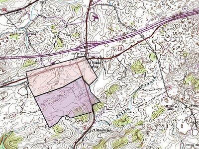
Washington Co. > Land Plats > Francis Kincannon Grants on the Old Stage Rd.
Click on any picture below to see a larger image. Four of the full size images contain additional information.
If you are not familiar with the general location of this land, locate one of the homes mentioned below from the list found on the Washington Co., Virginia Homes Google map.
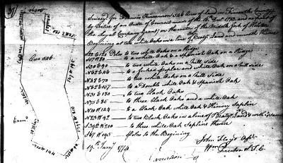
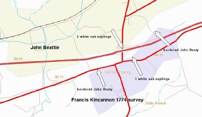
On Jan. 19, 1774 Francis Kincannon had 546 acres surveyed in what was then Fincastle County. The property was part of the Loyal Co. grant on the waters of the Middle Fork of the Holston River. The long northern boundary of Francis' land was contiguous with the southern boundary of a 2,183 acre tract settled by John Beattie.1
The Revolutionary War halted the granting of land from the English crown. Yet no system was in place enabling the Commonwealth of Virginia to grant title until the Land Office Act of 1779. In the intervening years Francis lived on his survey, built a cabin and raised a family. He also either erected a separate structure used as a fort, or fortified his own home in such a way that it was used as a fort. Either way, reference to Kincannon's Fort exists in Rev. War pension records.2
Following the war Francis was entitled to 400 acres based on his having settled the land in 1769. The certificate granting him the right to the land noted that it had been originally surveyed on 19 Jan. 1774. However, Francis' 1774 survey included more than 400 acres. He acquired the surplus acreage under a separate grant based on Virginia Land Office Preemption warrant #1,997, dated 22 Dec. 1781. The Old Stage Road (present day Rt. 11) crossed both parcels as it traversed Washington County.
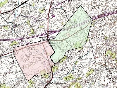
Perhaps because his land was to be granted as two separate parcels, Francis had the land resurveyed. When he did so the metes and bounds varied considerably from those of the 1774 survey. The new surveys created two parcels totaling 718 acres:
| pink | granted 5 July 17853 | 328 acres | surveyed 27 Dec. 17834 | based on settlement in 1769 |
| green | granted 5 July 17855 | 390 acres | surveyed 28 Oct. 17826 | based on pre-emption warrant |
Francis Kincannon died in 1795. His will left the 328 acre settlement tract to his son Mathew. The 390 acres to its east went to Mathew's brother George Kincannon. The will also encumbered the men to pay specific amounts to their brothers James, Andrew, and Francis Kincannon, and sisters Mary Smith, Elizabeth Porterfield, and Betsy Scott.7
George and Ann Kincannon sold 70 acres from the northwest corner of their tract to James and Isabella Clark on 12 Feb. 1798 (brown tract).8 James and Isabella built a log home on the property (gray arrow); see James and Isabella Clark home).
George added 8 acres of unclaimed land along the southwest edge of his remaining 320 acres on 27 Sept. 1800 (dark green sliver).9 Then, on 19 Oct. 1807, George and Ann sold the balance of the tract to Bazel Talbert for $2,666.66 (green tract).10 Bazel and his descendants operated an inn along the Great Road as it ran across this property (green arrow). It is likely the inn was originally built by a member of the Kincannon family (see Old Stagecoach Inn).
The disposition of Francis Kincannon's 328 acre settlement tract is more complex. On 13 Dec. 1805 Mathew and Leah Kincannon sold the full acreage (pink tract in figure 3) to John Robinson and John Edmiston for £1,000.11 John Edmiston's sister Elizabeth Edmiston was John Robinson's wife. The deed description included the following neighbors: George Kincannon [east], [John] Orr [southeast], Henry Jones [south], [James] Dysart [west], and [John] Beatie's “old patent line” [north].
John Edmiston and John Robinson did not hold the full 328 acres for long. On 18 Jul 1808 they sold the southern part of the tract, totaling 182 acres, to Moses Edmiston [John Edmiston and Elizabeth (Edmiston) Robinson's brother] for £500 (purple tract).12
This left John Edmiston and John Robinson jointly holding the remaining northern acreage. On 16 Oct. 1812 John Edmiston sold his interest in the land to John Robinson for $1,586.67.13
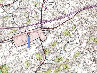
John Robinson then executed a deed on 15 Feb. 1814 to the trustees of Glade Spring Presbyterian Church formally transferring title to 2 acres of land on which sat their church and cemetery (black square/blue arrow).14 The land had been gifted to the congregation by Francis Kincannon, but Francis died before a deed was executed. As the land then passed to Francis' son Mathew Kincannon, and then from Mathew to John Edmiston and John Robinson, and then to John Robinson alone, the obligation transferred with it.
John and Elizabeth Robinson were the parents of 5 sons. When John died in 1826 he left the bulk of his land to his son Moses, setting aside 10 acres each for sons John and Ebenezer Alexander.15 Neither Moses or John Robinson married, and their wills left Ebenezer Alexander eventually owning all their father's land. However in the intervening years the 3 brothers had both added to the land and sold acreage from it:
| Bought: | ||||
| pink 1 | 27 Apr 1833 | William & Rhoda Beattie to Moses & John Robinson16 | 23 acres | $10 acre |
| pink 2 | 27 Apr 1833 | William & Rhoda Beattie to Moses & John Robinson16 | 130 acres | $10 acre |
| Sold: | ||||
| blue 4 | 23 Sept 1837 | Moses & Ebenezer Robinson to Nickerson Snead17 | 35+ acres | $900 |
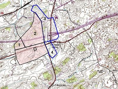
Nickerson Snead also purchased land from William & Rhoda Beatie on the same day as Moses and John Robinson.16 Nickerson's purchase (blue outline 3) was for 135 acres and was also sold for $10 an acre. It sat north of and adjacent to the land Nickerson bought a few years later from Moses & Ebenezer Robinson. Nickerson built a brick home on the north side of the Great Road (white arrow; see Washington Co. Homes and Buildings for a view of the exterior). The structure sat very near the boundary between the two parcels. Although a plat made with the old metes and bounds suggests it fell just within the former Kincannon/Robinson acreage, it is impossible to know for sure without additional information.
The southern half of Francis Kincannon's original 328 acre settlement tract (purple land in Fig. 5) returned to Robinson ownership in March 1837 when John, James and Ebenezer Alexander Robinson purchased the land from the estate of Moses Edmiston18. In May 1847 the 3 Robinson brothers sold 39 acres back to Parker Smith and his wife, Ann (Ryburn) Orr.19 James Robinson appears to have eventually owned the rest of the parcel.
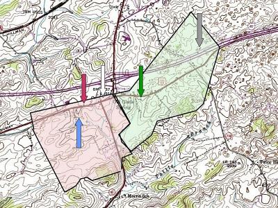
John Robinson died in 185220; his brother Moses died in 1857.21 Having no descendants, they left their share of the Robinson land, including the land acquired from William Beattie, to their brother Ebenezer Alexander Robinson. Ebenezer married Rebecca Fulton in 1854.22 They built a large brick home in the vicinity of the original John Robinson log cabin (see Robinson homes).
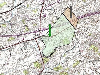
Figure 8 shows the location of the E.A. Robinson home (burgundy arrow) as well as the other 4 structures discussed previously - all overlaid on a plat of Francis Kincannon's 1782 grants.
E.A. and Rebecca Robinson sold several sections of their land over the years, including 10 acres to Glade Spring Church in 1867 for a parsonage.23 The parcel sat on a slight hill south of the church. In 1869 they sold 35 acres to Peter Clark24 and in 1873 they sold 16+ acres to John M. and Thomas B. Clark.25 Both parcels sat on the far west side of Francis Kincannon's settlement tract. Additional transactions have no doubt altered the shape and size of the original Kincannon grants.
Citations
- [S3194] Montgomery Co., Virginia Surveyor's records Vol. 1, 37. The 546 acre survey in Fincastle Co., VA, dated 19 Jan, 1774, was made for Francis Kincannon by virtue of an order of Council made the 16th Dec. 1773 [Fincastle Co. no longer exists; many of its surviving records are filed in Montgomery Co., VA].
- [S3219] George Hufacre declaration dated 12 Feb. 1833 at Knox Co., TN; George Hufacre Revolutionary War Pension Application File S1826; RG 15; (National Archives Microfilm Publication M804 - Revolutionary War Pension & Bounty Land Warrant Application Files. Digital images viewed 15 Jul 2013 at www.fold3.com.
- [S1438] Virginia Land Office Grants Q: 395; 5 Jul 1785, granted to Francis Kincannon, 328 acres on the waters of the Middle Fork of the Holston River surveyed 27 Dec. 1783...by virtue of a certificate in right of settlement... entitled to 400 acres of land which was surveyed for him 19 Jan. 1774... actual settlement 1869, Library of Virginia Online.
- [S1937] Washington Co., Virginia Surveyor's records Vol. 1, p. 213.
- [S1438] Virginia Land Office Grants Q: 407; 5 Jul 1785, granted to Francis Kincannon 390 acres by virtue of Virginia Land Office preemption warrant 1,997 dated 22 Dec. 1781...surveyed 28 Oct. 1782, Library of Virginia Online.
- [S1937] Washington Co., Virginia Surveyor's records Vol. 1, p. 22.
- [S616] Francis Kincannon will (1795), Washington Co., Virginia Will Bk 2: 65. The will was written 3 March 1795 and recorded 15 Sept. 1795. Witnesses were David Snodgrass, Daniel Perkins and William Beattie. James Kincannon and John Stewart were named executors.
- [S1400] Washington Co., Virginia Deed Book 2: 39-40.
- [S2534] Virginia Land Office Grants No. 46: 325, Library of Virginia Online. The grant was issued 27 Sept. 1800. The land had been surveyed 30 Dec. 1797 by virtue of a treasury warrant dated 23 Dec. 1782.
- [S1707] Washington Co., Virginia Deed Book 3: George and Ann Kincannon to Bazel Talbert, 19 Oct. 1807, for $2,666.66, 328 acres lying on the waters of the Middle Fork of the Holston River adjacent William Beattie, John Orr.
- [S1707] Washington Co., Virginia Deed Book 3: 424. Mathew Kincannon and Leah, his wife to John Robinson & John Edmiston, 13 Dec. 1805, for £1,000, 328 acres on the waters of the Middle Fork of the Holston River adj George Kincannon, [John] Orr, Henry Jones [James] Dysart.
- [S2152] Washington Co., Virginia Deed Book 4: 146. John Robinson and Elizabeth his wife, and John Edmiston to Moses Edmiston, 18 Jul 1808, for £500, 182 acres on the waters of the Middle Fork of the Holston River whereon Moses now lives; recorded 17 Jan 1809.
- [S1047] Washington Co., Virginia Deed Book 5: 139-140. John Edmiston to John Robinson, 16 Oct. 1812, for $1,586.67, one undivided moiety of a certain tract containing 180 ac, it being part of a tract of land purchased by the said John Edmiston and the said John Robinson from Mathew Kincannon and lying on the waters of the Middle Fork of the Holston River.
- [S719] Washington Co., Virginia Deed Book 5: 364. Indenture of 15 Feb 1814, John Robinson to ... [named] members of the Presbyterian congregation of Gladespring... [description of Francis Kincannon gift of land and obligation of subsequent owners to transfer title], 2 acres on waters of the Middle Fork of the Holston River, part of tract sd. John Robinson now lives on...
- [S618] John Robinson will (1826), Washington Co., Virginia, Will Book 5: 324.
- [S1044] Washington Co., Virginia Deed Book 11: 260-263.
- [S2526] Jack Hockett, Washington Co., Virginia Deed Book 17, 1844-1846, abstracting Washington Co., VA Deed Bk 17: 179. This deed was executed 23 Sept. 1837 but not delivered to the county clerk for recording until 28 Mar 1845.
- [S2562] Jack Hockett, Washington Co., Virginia Deed Book 13, 1837-1839, abstracting Washington Co., VA Deed Book 13: 9-11.
- [S2763] Washington Co., Virginia Deed Book 19: 34-36.
- [S2222] Jack Hockett, Washington Co. VA Will Book 12 1850-1853, abstracting Washington Co., VA Will Bk 12, p. 308.
- [S2146] Jack Hockett, Washington Co. VA Will Book 14 1856-1859, abstracted, abstracting Washington Co., VA Will Bk 14: 184.
- [S6] Thomas Colley, Washington Co. VA Marriages 1853-1880, p. 304. Ebenezer Alexr Robinson, 47, sgl, b. WCV, farmer, s/o John & Elizabeth Robinson marr Rebecca Fulton, 33, sgl, b. WCV d/o Robert R. & Sarah Fulton; 27 Jul 1854.
- [S3055] Jack Hockett, Washington Co., Virginia Deed Book 27, 1868-1870, abstracting Washington Co., VA Deed Bk 27: 355.
- [S3055] Jack Hockett, Washington Co., Virginia Deed Book 27, 1868-1870, abstracting Washington Co. VA Deed Bk 27: 615.
- [S3214] Jack Hockett, Washington Co., Virginia Deed Book 30, 1871-1874, abstracting Washington Co., VA Deed Bk 30:307.