Washington Co. > Land Plats > James Clark Land
Depending on how you reached this page, you may not have seen, but may be interested in: the James Clark page and/or the James and Isabella Clark home page.
James and Isabella (Breckenridge) Clark's original tract consisted of 70 acres sold to them in Feb. 1798 by George and Ann Kincannon.1 George owned a large tract of land continuing to the west of this parcel.
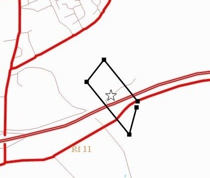
The double red line is interstate 81. The single red line below it is present day Rt. 11 which closely follows the Old Stage Rd. Present day Glade Spring is seen in the upper left corner.
The star indicates the general location of James and Isabella's home.
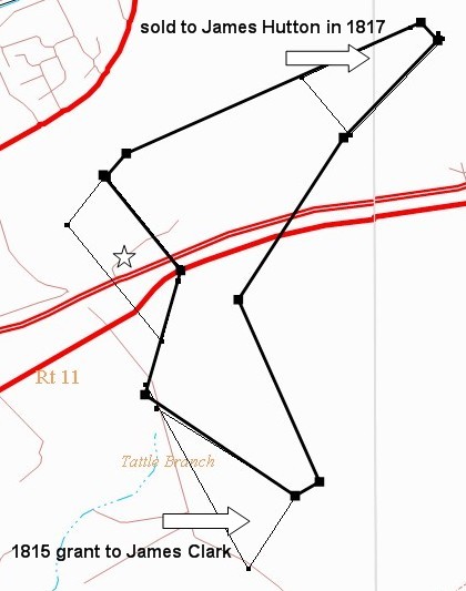
James acquired an additional 342 acres from James Braden on 7 Dec. 1807.2 In Sept. 1828, some years following James's death, a court ordered inclusive survey (heavy black line) was undertaken to identify the boundaries of this land (which also included another 58 acre parcel).3
The survey did not include an additional 50 acres granted to James in 1815.4
Interestingly, the survey did include a 53 acre parcel James had sold to James Hutton in 1817.5 James Hutton's heirs sold part of this 53 acres in Oct. 1828. Perhaps that impending transaction prompted the survey.
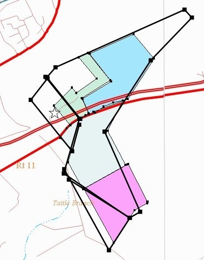
On June 22, 1812, James sold parcels to his sons James Jr. and John6:
- pink: James Clark Jr. - 100 acres for $170
- light blue: John Clark - 140 acres for $200
James' 1818 will left the land on which he was living to his sons Robert and Peter.7 It sat on the north side of the Old Wagon Rd. (approximate location of Rt. 11 today).
When the brothers divided the land Robert received the portion shown in green and dark blue. Peter received the uncolored tract on the west which included the family home.
On Feb. 26, 1831 Robert sold his share to his brothers John and Peter8:
- dark blue: Robert and Catherine Clark to John Clark - 122 acres for $507
- green: Robert and Catherine Clark to Peter Clark - 48.25 acres for $193
In 1858 John and his wife Mary (Beattie) Clark, divided their land (2 blue tracts) amongst their sons John B. and James Clark, further subdividing James and Isabella's original holdings.9
NOTE: On paper, the boundaries of the 1812 deeds (pink and light blue) do not overlap the outline of the 1828 inclusive survey (bold black line). However, the boundaries were actually the same. The discrepancy is due to errors in one or the other of the surveys - a common finding in early deeds.
Washington Co. Map
James and Isabella's home is indicated on the map below. Notice the field boundaries I've highlighted in orange. Two hundred years later we can still identify the northern boundary of James's land and the shape of the parcel he sold to James Hutton. The land to the north of James was originally part of John Beattie's huge tractCitations
- [S1400] Washington Co., Virginia Deed Book 2: 39-40.
- [S1707] Washington Co., Virginia Deed Book 3: 626.
- [S2349] Washington Co., Virginia Surveyor's records Vol. 2, 508-509.
- [S2601] Virginia Land Office Grants No. 65: 72, Library of Virginia Online.
- [S1988] Washington Co., Virginia Deed Book 6: 413.
- [S1047] Washington Co., Virginia Deed Book 5: 108-109.
- [S131] James Clark will (1819), Washington Co., Virginia, Will Book 4: 281.
- [S1772] Washington Co., Virginia Deed Book 10: 397.
- [S1045] Washington Co., Virginia Deed Book 24: 146.